3D VISUAL REALITY CAPTURE
CONSTRUCTION VERIFICATION
ADVANTAGES
People Respond To Visuals
Speeds The Communication Of Ideas
Visuals Improve Comprehension
Provides Mega Data At A Glance
Enhances Collaboration
Get Ahead Of RFIs And PCOs
Minimizes Amnesia
Hard To Argue With
Regularly Scheduled 360° Photos Help Manage Expectations
Keeps Stakeholders Informed
Builds Trust & Transparency
Enhance Weekly Meetings With Current Photos Of Progress & Problems
Improves Quality Of Information
Keeps Everyone ‘In-The-Loop’ — From Any Location
Easily Compare Day-By-Day Progress And Check On-Sight Inventory
Your Archived Walkthroughs Provide A Historic Review
Archived Visuals Allow You To Look Inside All Closed Ceilings & Walls
Reduces Pay App Disagreements
Manage Expectations & Schedules
Archives Historic Data
Compare ‘Plans-To-Actual As-Built’ Conditions — Side-by-Side
Pull Measurements Remotely Off Of The 360° Photos
GAIN THE COMPETIVE EDGE
SAVE TIME & MONEY
THE 360° VIRTUAL WALKTHROUGH
Visually Capituring Every Aspect Of The Build
Why You Need It
• Stakeholders Peace-Of-Mind = Win More Bids
• Captures & Supplements BIM Mega Data
• Communication & Collaboration at All Levels
• Reduces PCO’s & RFI’s
• Reduces Billing Issues
• Transparency thru Technology
• Quality Assurance & Historic Archives
How We Do It
• We Help You Define Your Recording Needs
• We Help You Determine A Capture Schedule
• We Capture Your Visuals On Job Site
• We Process & Store All Captured Data
• We Register & Post Visuals To Your Platform
• We Respond To Your Special Requests
• We Develop Presentation Packages
THE PROCESS
ADDITIONAL BENEFITS
People Respond To Visuals
Speeds The Communication Of Ideas
Visuals Improve Comprehension
Provides Mega Data At A Glance
Enhances Collaboration
Get Ahead Of RFIs And PCOs
Minimizes Amnesia
Hard To Argue With
Regularly Scheduled 360° Photos Help Manage Expectations
Keeps Stakeholders Informed
Builds Trust & Transparency
Enhance Weekly Meetings With Current Photos Of Progress & Problems
Improves Quality Of Information
Keeps Everyone ‘In-The-Loop’ — From Any Location
Easily Compare Day-By-Day Progress And Check On-Sight Inventory
Your Archived Walkthroughs Provide A Historic Review
Archived Visuals Allow You To Look Inside All Closed Ceilings & Walls
Reduces Pay App Disagreements
Manage Expectations & Schedules
Archives Historic Data
Compare ‘Plans-To-Actual As-Built’ Conditions — Side-by-Side
Pull Measurements Remotely Off Of The 360° Photos
What Others Say
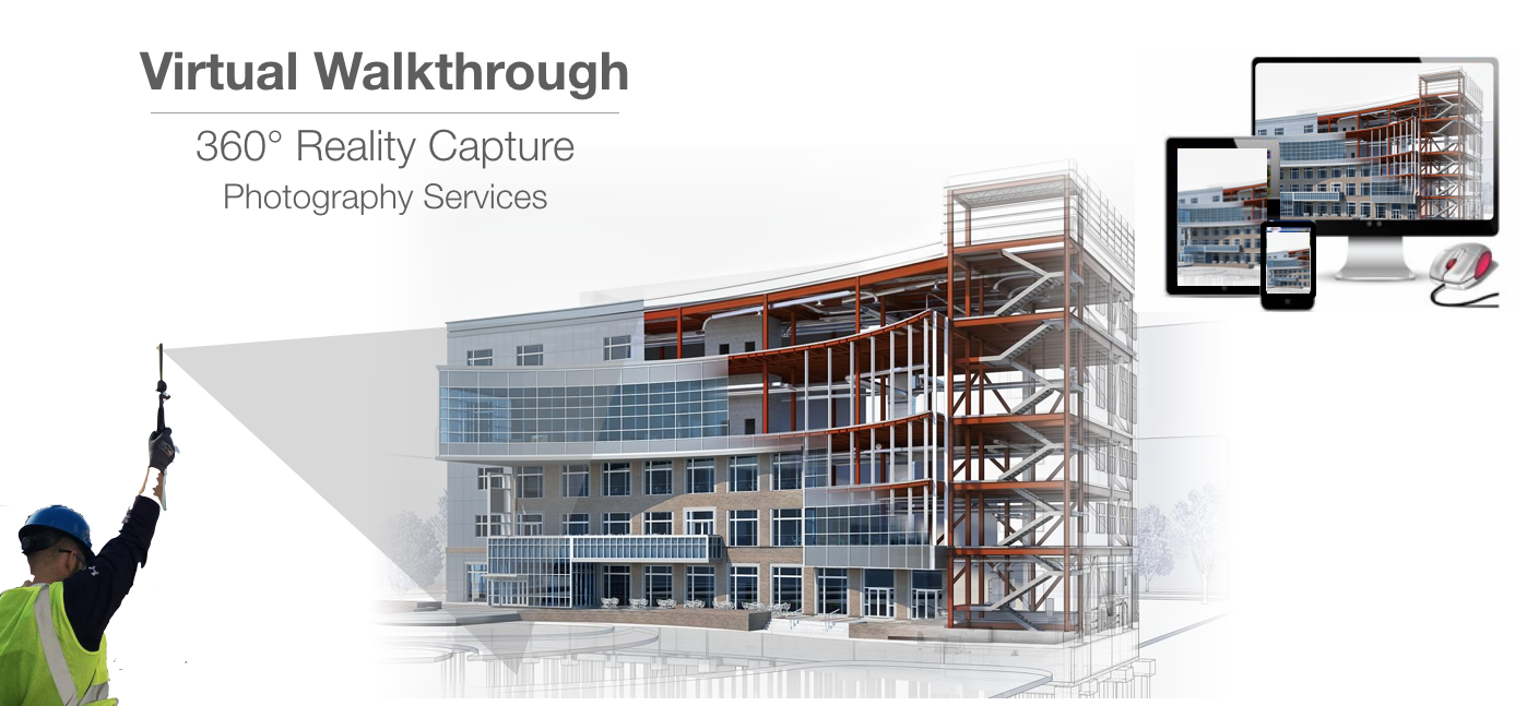
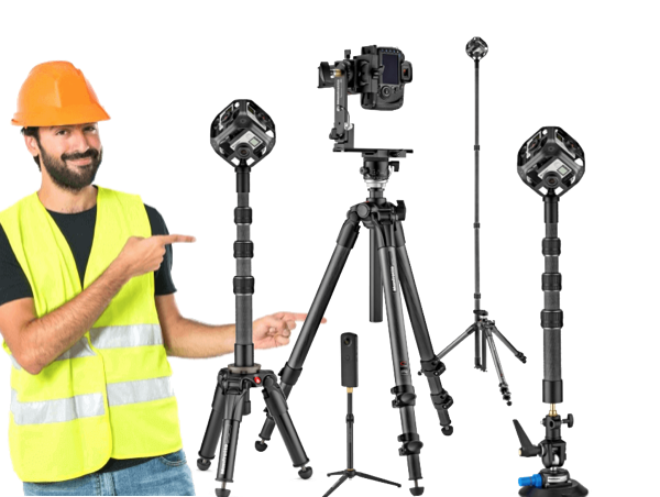
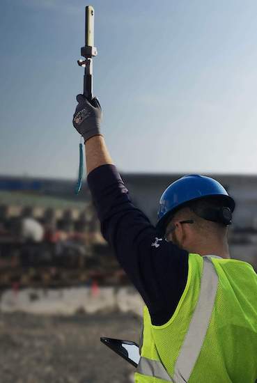
360° Virtual Walkthrough photography on construction sites is sort of like Google Street View at a smaller scale. High-definition images are captured as we walk through your job site with a monopod and a special 360° camera. We quickly capture the sights and sounds of your job site from all angles.
This technology has made rapid advances in recent years and it is rapidly proving itself in the construction industry.
“These photographs are game-changing,” said Albert Zulps, Regional Director, Virtual Design, and Construction at Skanska. “Once you capture that space you can actually go back in time and look at archived versions of every photograph. You can step back in time and see inside the sheetrock, look up and down into the wall, ceiling, and floor areas of every room. This is a huge time and expense saver when you need to understand the potential complications of a change or modification. And you can do it all without leaving your desk.” “For us, three-sixty-degree photography is a tremendous time and money saving tool. We can monitor job site inventory and worksite safety issues, at any point in time, from any location,” he said.
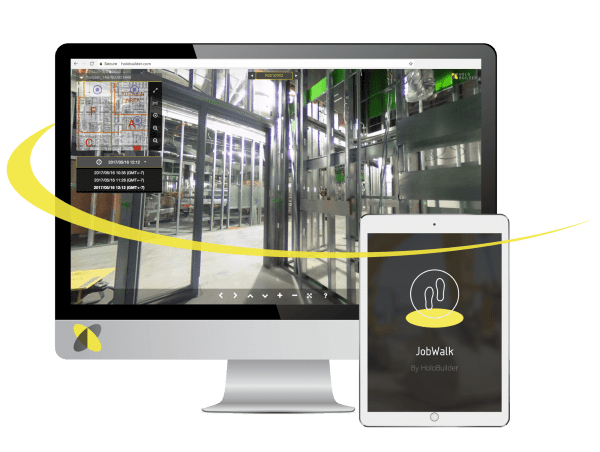
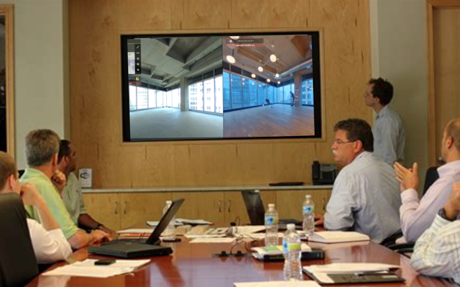
“The resolution is just phenomenal,” said Tony Colonna, senior vice president of innovative construction solutions at Skanska. “The new photography tools and techniques allow management, contractors, and stakeholders to basically take anyone on a virtual walkthrough of the site, without even being there.” The ‘look-around’ 360-degree video is almost like being there, he reports. “You’re in complete control. You just select the floor level you want, click on the floor plan map and you can instantly enter any room. You can move forward and back, right and left, and just stop and look around. You can look up and look down and you can even pull up detail shots of special items for clarification. Unlike traditional photographs or traditional video, your field of view is not limited to where the camera was pointing. With the 360-degree virtual walkthrough you have complete flexibility.” “The software even allows you to pull rough measurements from anything in view.”
When you combine 3D Scanning and 360° mobile mapping technology together it promises to help AEC (architecture, engineering, and construction) professionals advance their ability to quickly and easily verify ‘as-built’ field data with design models.
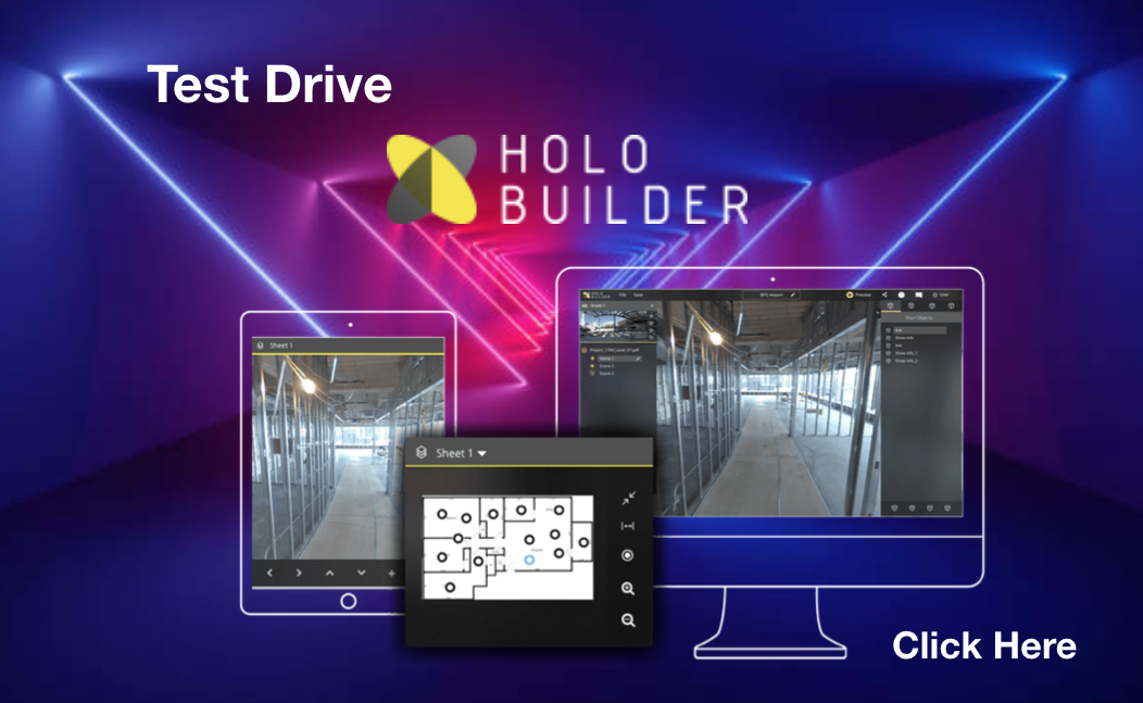
Click Here to look at and tryout a Sample Virtual Site.
Be sure to ‘click & drag’ to look up & down, and all around.
How It Works
360° Virtual Walkthroughs are series of photos, taken with special 360/3D cameras. The images are methodically captured by Meyer3D, from specific key locations. They are captured on a schedule of your choosing, daily, weekly, and/or upon special request or milestone.
Over time, we strategically capture all aspects of your project. We capture images of what’s inside the walls, in the ceiling, and in the floor or slab of every room. These photos show workmanship, materials used, materials on the ground at any specific point-in-time, as well as equipment and procedures in use.
Since people are visual, these photos save time during weekly meetings, eliminating confusion, and prove existing conditions. This visual information is invaluable when collaborating with contractors, inspectors, and stakeholders. They are vital when verifying pay applications, planning change orders, and assessing liability for errors.
The volume of information that is captured is massive. It’s captured, stitched together, stored and securely archived by Meyer3D.
After processing the information, we present it to you in an easy to use ‘online’ SaaS software solution, hosted by our partner company Holo Builder. Since it’s online, you can authorize others to view the information from their computers, world wide.
By simply clicking and dragging, the you can rotate the view straight up or down, or spin all the way around, in a 360° sweep.
Get your feet wet…
Click Here to look at and tryout a Sample Virtual Site.
At Meyer3D, we only use the latest in scanning hardware and cameras, coupled with a full suite of software toolsets to provide the deliverables you need. From registered ‘Point Clouds’ for your team to use with their software, to refined 3D CAD-to-BIM modeling, Meyer3D will provide the information you need.
SCOPE OF WORK
360° Virtual Walkthrough Services
- We Help You Define Your Recording Needs
360° Video Walk, 360° Room Snaps,
Target Specific Photos, Close-Ups,
Milestone Recordings, Interior / Exterior
Pre Wall & Ceiling Closure Recordings
- We Help You Determine Capture Schedule & Frequency
- We Help You Select Your Hosting Platform
- We Setup, Update, & Backup Your Hosting Site
- We Manage Your Hosting Site Security Access
- We Methodically Capture Visuals On Your Desired Schedule
Daily, Weekly, On Milestones, etc.
- We Provide All Equipment To Capture 360° Photos & Videos
- We Process, Stitch, and Render All 360° Shots During Post-Shoot
- We Locally Store, Archive, and Backup All Captured Data
- We Provide All Project Data In Hard Drive Format At Project Close-Out
- We Register & Post All Visuals To Your Cloud Hosting Platform
- We Upload & Setup Your Floor Plans Into Your Hosting Platform
- We Link Your Platform To Your Procore, Dropbox, or AutoDesk BIM 360
- We Provide “How To Use” Training For Your Platform As Needed
- We Respond To Any Special Milestone Reality Capture Requests
- We Work Closely With Each Project Manager
- We Develop Visual Presentation Packages Upon Request
OAC Meeting Presentations
Weekly Sub Coordination Meetings
Project Close-Out Archive Document Packages
At Meyer3D, we only use the latest in scanning hardware and cameras, coupled with a full suite of software toolsets to provide the deliverables you need. From registered ‘Point Clouds’ for your team to use with their software, to refined 3D CAD-to-BIM modeling, Meyer3D will provide the information you need.
Processing The Data

“The time we spend in the field is minor, when compared to the time required to process, break down, and register all of the captured data into the clients selected platform.” “If the client can’t early access the information, if they can’t jump right to what they are looking for, then they won’t capitalize on the power of the information.”
“Our real magic happens when we process and enter this massive amount of information into an easy-to-use software solutions that makes the information ‘One-Click Simple” for our clients to use.”
“Typically… One hour of 360° Virtual Walkthrough field recording takes 3½ hours to properly process, register, and back-up the videos and images. Sometimes more, depending upon the client’s special needs and deliverable requirements.”
Hard For Us — Easy For You
Meyer3D takes advantage of several very powerful SaaS software solutions to host our clients information and provide them with the easy access to the data they need and desire.
Our clients simply select one of our partner hosting firms [annual fee applies] and we handle everything else. We will setup their hosting account and upload the floor plans to be used as capture point location templates. We will also teach everyone in the client’s loop how to login to their secure site.
Since all of your information and data is secure, we will also setup and maintain the required Security Authorizations based upon the client’s shifting needs. You decide who gets to see what. From short term limited access to long term full access, we handle all of the operational hassles.
We make everything easy to use. Invited participants simply login, locate the area of interest within a floor plan map, and click on the link to view all the 360° photos, videos, still shots, and reference data registered to that location. They can even jump back in time by selecting a previously archived date.
“If you really want to think about how everything ties together, it is all about collaboration,” Colonna said. “When you look at the construction industry, you’re trying to effectively manage a lot of different entities, from the design team, to the owner, to the builder, to all the contractors. What Skanska is doing as a construction manager is finding new ways to collaborate with all those teams. It’s really about, how do we use more visual technology to help us work better together?”
3D Scanning and 360° mobile mapping technology promises to help AEC (architecture, engineering, and construction) professionals significantly advance their ability to verify as-built field data with design models.

People Are Visual… Make The Most Of It!
Meyer3D, LLC
10764 S. 93rd East Ave.
Tulsa, Oklahoma 74133
(918) 899-1932
All Rights Reserved
© Meyer3D 2023
OKLAHOMA TITLE 245 LEGAL NOTICE: Meyer3D, LLC preforms support work for firms that are licensed under title Oklahoma Title 245.
Meyer3D, LLC DOES NOT claim to be a licensed Professional Engineer or a licensed Land Surveyor company and it is NOT licensed under OK Title 245 as such.